|
|
Using GPS Function Overview
| Article ID: ART134580 |
| |
Date published: 05/13/2015 |
| |
Date last updated: 11/16/2015 |
Description
Using GPS Function Overview
Solution
Using GPS Function Camera location information (latitude, longitude, and elevation) based on acquired GPS signals can be added to the still images and movies you shoot, or this information can be logged separately. In addition to geotagging, the camera clock can be updated automatically. Before using GPS functions, make sure the date, time, and local time zone on the camera are set correctly, as described in “Setting the Date and Time” GPS: Global Positioning System When using GPS functions, keep the following points in mind. In certain countries and regions, the use of GPS may be restricted. Therefore, be sure to use GPS in accordance with the laws and regulations of your country or region. Be particularly careful when traveling outside your home country. Be careful about using GPS features where the operation of electronic devices is restricted, because the camera will receive GPS signals. Others may be able to locate or identify you by using location data in your geotagged still images or movies. Be careful when sharing these images or GPS log files with others, as when posting images online where many others can view them.
Where to Use GPS, and How to Hold the Camera 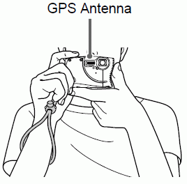
Use the camera outside, where there is an unobstructed view of the sky. (GPS functions will not work correctly indoors or in other areas away from GPS coverage.)Hold the camera correctly, as shown, for easier GPS signal reception.Keep your fingers or other objects off the GPS antenna.How to Carry the Camera When Using the Logger Function For better GPS signal reception, try to keep the GPS antenna pointing up, toward the sky. When carrying the camera in a bag, put it in the bag with the GPS antenna pointing up, and try to put the camera in an outer section of bag. Places With Poor GPS Coverage - Location information may not be recorded, or inaccurate information may be recorded where GPS signal coverage is poor, such as in the following places.
Indoorsunderground near buildings in valleys in tunnels forests near high-voltage power lines or mobile phones operating on the 1.5 GHz bandinside a bag or suitcaseunderwater when traveling across great distances when traveling through different environmentsEven in other places, GPS satellite movement may interfere with geotagging and cause missing or inaccurate location information, or the information may indicate that the camera has been used elsewhere even if it has not. GPS signal reception may take longer after battery replacement, or when you have not used GPS functions for some time.
|
